The classic Annapurna Circuit trek first became accessible to the world of adventure travellers as recently as 1977, when the Nepalese Government derestricted the Manang Valley, which had previously been closed on account of its proximity to the Tibetan border.
The Name Annapurna came after the Mount. Annapurna, which is the 10th highest mountain in the world. Annapurna is a series of peaks in the Himalaya, a 55-km-long Massif whose highest point, Annapurna I, stands at 8,091 m (26,538 ft). It is located east of a great gorge cut through the Himalaya by the most famous river, Kali Gandaki and which separates it from the Mount Dhaulagiri. Annapurna is a Sanskrit name which is translated as Goddess of the Harvests. In Hinduism, Annapurna is a goddess of fertility and agriculture. The Region, Annapurna is surrounded by many Himalayan ranges which include the Annapurna range, Dhaulagiri and Machhapuchhre - the famous fish-tail mountain that dominates the skyline above Pokhara. In addition this area possesses the Kali Gandaki, the world's deepest gorge.
The Region Annapurna is famous for its trekking. In this region there are three major trekking routes, Jomsom Muktinath, Annapurna Sanctuary which is also called Annapurna Base Camp and Annapurna Circuit. About two-thirds of the trekkers in Nepal visit the Annapurna region. The area is easily accessible, hotels in the hills are plentiful, and treks here offer good scenery of both high mountains and lowland villages. In this Region there is one project known as ACAP (Annapurna conservation Area Project) ACAP was established in 1986 under the guidance of the King Mahendra Trust for Nature Conservation. The project covers the whole Annapurna range, more than 7600 sq km. In an inventive advance to environmental protection, it was declared a "conservation area" instead of a national park. A large number of people live within the protected region.
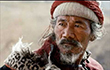
Annapurna Conservation Area offers varieties of flora and fauna form sub tropical to pine and you will grace by the heart touching blossoming rhododendron on your way. This region is also the home to copious wildlife like pika, blue sheep, snow leopards, tigers and Himalayan thar. Multiplicity of birds including multi colored Impeyan, koklas and blood pheasants, offer you their natural beauty. In this region you will encounter with the Gurungs and Thakali people whose unique culture and religion makes you surprise. You will experience how friendly and open hearted these people are, and you can get a taste of their lifestyle by staying in their house and knowing their way of living and their culture and tradition.
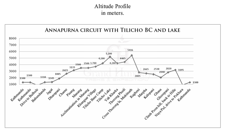
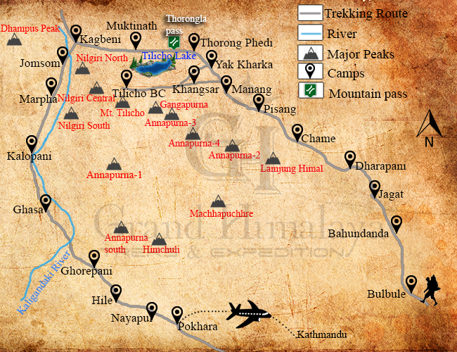
We have customized this route as it is basically the same as Annapurna Circuit, from Manang instead of taking the valley north to Tanki Manang and Yak Kharka. This route goes to the main valley to the west passes through the Khanshar Village (The Last Village of Nepal) and trek up to Tilicho lake, then we travel to Yak Kharka then up to pass of Thorung La at elevation of 5,416m.
A very warm welcome to the Kingdom of Himalayas. Upon your arrival at the Tribhuvan international airport our representative welcomes you and assists you transfer in your hotel in Kathmandu. After time to get refreshed, evening you'll meet and transfer for welcome dinner in one of the typical Nepalese restaurant in the heart of Kathmandu i.e. Utsav or Nepali Chula (Kitchen). Here you will not simply experience the traditional Nepalese dish but will be entertained with Nepalese traditional dance and folk songs. After the dinner, you will be transferred back to your respective hotel.
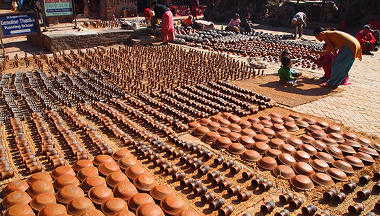
Kathmandu is the historical and cultural heart of Nepal and has been a popular destination for tourists ever since Nepal opened its doors to visitors. The city presents a wonderful mix of Hinduism, Tibetan Buddhism and Western influence in the Valley. Bauddhanath: Stupa with its 130 ft. dome. One of the world's largest Stupa, Bouddha is generally acknowledged to be the most important Tibetan Buddhist monument outside Tibet. Pupshupatinath Temple: Pashupatinath is considered one of the holiest shrines of all the Hindu temples. The temple has remained the presiding deity of ruling Nepalese Royalty. -After the city tour, our leader or guide will do the final briefing of the expedition. They will also take the opportunity to check the members' personal equipment as the city bazaars and climbing shops will provide the last chance to correct any deficiencies. Overnight at Hotel.
Driving out of the Kathmandu valley gives us some excellent mountain views on the road to Pokhara. This is really pretty good as far as Dumre where we may have a short break depends on the traffic, if not we will continue to Besi sahar for our lunch. From Dumre the recently upgraded road heading north to Besi sahar, is a bit less predictable. Mostly fine, but any monsoon landslides or damage to the surface take longer to get fixed. Were still driving through wonderful countryside though, and we should reach Besi Sahar (823m) by mid afternoon, in good time for couple of hours on the trail. We will stop here for lunch and guide will have to register your trekking permit while you stop for lunch. After lunch, we continue to Bulbule, driving to Khudi (815m), through mostly Gurung villages we go up the west bank of the Marshyangdi khola where it is joined by the Khudi khola, which drains the east of Lamjung Himal. From Khudi we commence our trek. Today we aim for Bulbule (850m) there are few local lodges.
From Bulbule, the valley changes character, narrowing to a gorge. Crossing to Bulbule, we pass the first of the waterfalls for which the Marshyangdi is famous. On through Terante we reach Ngadi (915m), where we will generally stop for short break perhaps tea/coffee. Crossing the Ngadi khola we then climb a long, and sometimes hot, hill through Lampata we reach Bahundanda (1310m), Brahmin Hill, our lodge stop on a saddle ridge with an excellent views to the north and of the surrounding hillside Gurung settlement. Your guide will give you briefing every evening for the following day.
Gentle descend with bit careful on the slippery rocks, to another stream with a traditional cantilevered bridge, the trial here is carved out of the rock wall itself. Through Khanegaun, we counter to Shyange (1135m) and stop here for lunch. Then we cross a large suspension bridge over the Marsyangdi gorge, and continue to Jagat. Before reaching Jagat there is a curved road on a huge rock cliff, and sometime we might cross with mules (main transportation of public supplies of the area) it is most important to stand in the wall all the time when you cross with these mules/even with porters to secure yourself. There were few accidents events in the past that trekkers been pushed by mules and fallen down long way down to the Marshyangdi river. Never stand and wait on the down hillside. Jagat an old customs post on the Tibetan trade route still inhabited mostly by Bho Tiya (Nepali term for Tibetans) traders. Our lodge accommodation will be in the best available lodge at Jagat (1345m).
After breakfast, we start our trek walking via Chamje(1390m) is just beyond Jagat. We notice that the vegetation is feeling less tropical, and that the people are starting to feel more Buddhist, though still with the Nepali custom of blending their cultures-most here are actually Hindu. After Chamje there is a more noticeable change to both landscape and people. From here most of the houses are made of stone, instead of the mud rendered lattice-river. Entering a broad valley we reach Tal (1665m), our lunch stop. We have entered Manang District. Continuing up the east bank on another rock cut path, we cross to Dharapani(1885m) our lodge stop, a fine village at the end of the confluence of the Marshyangdi and Dudh khola which leads up to the Larkya Pass to the north of Manaslu. Evening discussion regarding the following day trip plan with guide after dinner.
After the neighbouring village of Thonje, (where we have resister our trekking permit again) we carry on up the west bank taking the path to Bagarchap (2105m). Here the Tibetan style flat roofs are a clear indication of the reduction in rainfall to the area as we enter the shado of the Annapurna range. Past excellent views of the east face of Lamjung Himal, we get to Latamarang (2355m) for lunch, and then take the easy path to the district administrative centre of Chame (2615m), our lodge for the night.
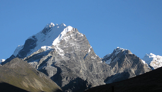
Todays highlight is the Paungda Danda rock face, an interesting and large rock slab. At our camp, Pisang peak (6,191m) looms over Pisang village. We follow up the narrow forested valley to the old Khampa settlement at Bhratang (2845m), our lunch stop, once a centre for this fierce Tibetan warrior's resistance to Chinese occupation. We cross over and begin to climb up through the forest away from the river. The silence itself is dramatic as we round this pine forested ridge. We continue down to Pisang (3135m) our lodge stop. The Tibetan feel of the village is unmistakable, fine tapering walled houses and long lines of prayer wheels and mane walls. There is an excellent short detour for those with some spare energy, up to Pisang gompa (3230m) across on the north bank, with amazing views back of the huge north face of Annapunra II.
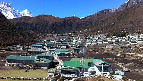
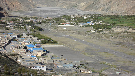
This is the Nyesyang region of Manang; the people are well travelled traders. There is a choice of two routes today: a shorter direct one the along the south bank valley floor via Hongde airstrip, or a more interesting, but fairly longer route higher on the north bank through the village of Gharyu and Ngawal. This maybe 3hrs longer but offers such magnificent views of the mountains to the south. Both meet at Braga cliff side village (3450m) , below its 900 year old gompa(monastery) of the Kangupa sect of Bhuddhism, sadly now little used. The main village of Manang (3500m) our lodge stop for the next two nights or only just beyond.
Manang is a fascinating village, the chief Buddhist village that gives you its name to the area. As such it's ideal for our essential acclimatization rest day before taking on the Thorong-La. There are excellent side trips such as the short climb to the Cliffside Bod-zo Gompa where the lama performs a blessing ceremony to protect us on our journey. Everyone should aim to manage some ascent to further our acclimatization, if only to this little monastery. The more energetic may wish to visit the high village of Khangsar on the opposite bank. A good day's round trip and well worth the effort.
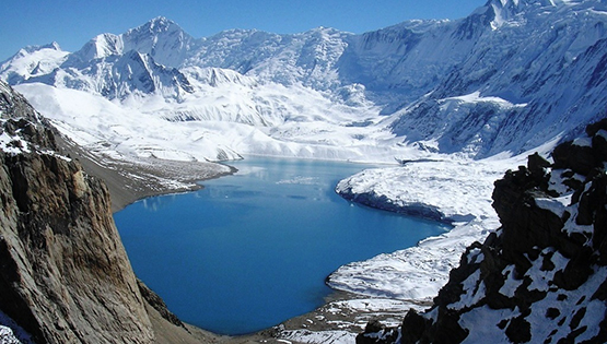
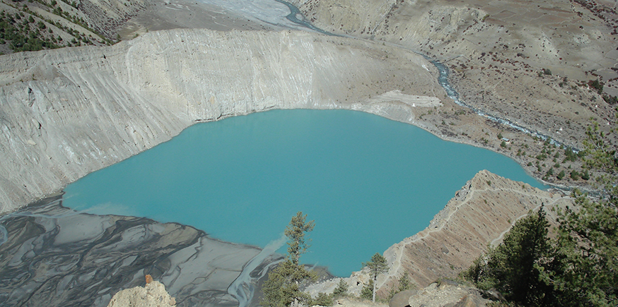
After acclimatization in Manang, we continue to Tilicho Lake through the western gates down the river. After crossing the Khangsar Khola on the bridge below Khangsar, we ascend the slope to the village. Khangsar remains following old Tibetan style and is known as the last village of Nepal. We overnight at a guesthouse.
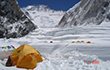
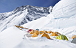
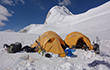
We continue from Khangsar on a large path, past a gompa (monastery). The route lies on a recently constructed path toward a high ridge. We come to an intersection, where one path maintains the altitude, traversing the slopes toward a narrow valley. This path is old and difficult, as it goes on steep screed. The other path is new and ascends toward the line of the ridge. This path reaches a high crest and descends on switch backs carved out through the screed slopes to a side valley. At its bottom is a brook and Tilicho Base Camp.
The journey starts early in the morning - around 6a.m. - as we try to avoid the wind. From base camp to the Tilicho lake takes about three to four hours. The cold and barren area of Tilicho Lake is claimed as highest lake in the world. After we spend some time around the lake, we return to Tilicho Base Camp.
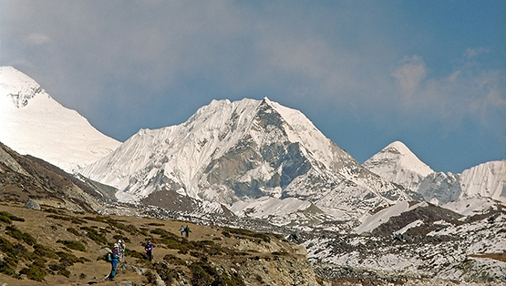
As you get higher in the Himalayas, it's important to be aware of the effects of altitude sickness. It is essential for proper acclimatization to make stops between Manang and Thorong Phedi. As we leave Manang, the path gradually ascends higher up the valley; however, at this altitude, you will definitely feel the affects of the higher elevation. We will overnight at the village of Yak Kharka. If you still have some energy, there are several additional shorter hikes you can take around the village in the afternoon.
Again it is not far to Thorong Phedi (4405m)- meaning literally the bottom of the Thorong pass. There is a lodge at Thorong high camp. If we are lucky enough to get accommodation for the night in this lodge, which offers the most amazing views, also it would helps us to minimize the following day. It is a truly spectacular setting perched in a craggy arena between the peaks. This if the last possible lodges before the pass, and it would not be recommended to sleep higher at this stage anyway. We may have to spend the night at Thorong Phedi at some stage. However, we are here (Thorong pahedi) well in time for lunch, decision will be made while we stop for lunch. The most important thing here is keep drinking as much as you can to keep body from dehydrated. Stay warm all the time. If you feel any altitude sickness symptoms appearing on you then you must let to the any of friends or staffs.
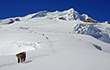
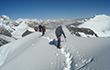
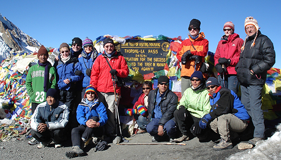
This is the big challenge of the circuit route, we know that once over the pass the rest of the trek is plain sailing in comparison. We need an early start. Steady uphill all the way we wind our way step by step. We deliberately set a slow steady, sustainable pace, taking short rests to watch the unfolding views. The immediate ground is dry and bare as even the heather shrubs and grasses thin out. Its dramatic enough though, almost lunar especially in the early light. Once shallow gully opens to the next and we reach several false crests which tease us into thinking we have reached the top. But the real Thorong La (5416m) finally comes into sight, marked by a large cairn and decked with colored prayer flags. Its takes about 5-6 hours from Thorong Phedi, and 4-5 hours from Thorong high camp. In the spring particularly there could well be some snow on the ground at the top, but the path should be well trodden. (Bear in mind that this is very definitely a trek, we will not attempt the pass in anything approaching mountaineering conditions.) The rewards for our hard walking are more than enough, the views are spectacular from this dramatic transition between the Manang valley behind and the Kali Gandaki River spreads out in front, with the massive from of mighty Dhaulagiri on the far side visible from just beyond the pass. The sculpted ice peak of Thorontse is to the north; Khatung Kang is to the south. We take a good long rest on the top, and eat the packed lunches we brought up from the lodge which pre prepared. The decent is gradual at first, becomes quite steep for a while and then even out again. There are great views all the way, and it takes about 3-4 hours down to Muktinath (3800m), our welcome night stop. Muktinath is a really remarkable place, sacred to both Hindus and Buddhists. Legends say that Brahma, the creator, made an offering here, lighting fire on water, which can be seen in the small Buddhist Gompa below the mail Hindu Mandir (temple). Hindus believe that bathing in the 108 boar's head water spouts brings salvation after death to the pilgrims comes here all the way from India. There is a mutual coexistence between the two religious, so uniquely typical to Nepal, Buddha is said t be the 8th incarnation of the Hindu god Visnu, and Buddhists take the image of Visnu to be that of the Bodhisattva Avalokiteshwara of whom the Dalai lama is said to be a reincarnation. Layer upon layer of deeply felt tradition reinterpreted through centuries of devotion. Padmasambhava, the great sage revered for bringing Buddhism to Tibet in the 8th century, is said to have meditated right here, but whether this gave birth to the legends or merely continued them is difficult to say. Then the 84 siddha (great magicians) left their pilgrim staffs here on their way to Tibet. They are believed to have grown into the original beautiful poplars that surround the site all very plausible.
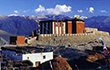
We now take two short easy days to relax after the pass. We need the morning to rest and look around Mutkinath properly. Onle after lunch we do start a gradual decent through this dramatic wide valley. We can see that it is steeped in history. Indeed we are on the edge of Mustang, the great Buddhist civilization to the north on the borders of Tibet. We pass the ruined fortress of Jharkot and the village of Khingar (3200m), along with other dramatically located ruins across the valley. This brings us down to the fields around Kagbeni (2805m) on the Thak Khola as the upper reaches of the Kali Gandaki are known. Our fascinating lodge stop is the southern-most of the great Mustang villages and its architecture is typical of this unique culture. Dominated by the impressive dzong (fort) and gompa (monastery), the village beneath has interlocking houses cut by little alleys and a flat roof-scape of glazed dining rooms with evocative views up valley to the restricted kingdom beyond.
Now we are entering the land of the enterprising Thakali, the Buddhist people who (like the Sherpas over in Khumbu) controlled the ancient trade route between the Tibetan plateau and the Nepali foothills and Indian plains beyond. Grain from below was exchanged with salt from above, and a great many precious commodities besides. The Kali Gandaki is counted as an important branch of the famous lilk road, linking east and west, north and south on a massive scale. Down its wide flat valley heading south, the landscape changes yet again as we past between twisted stratified rock formations to Jomsom (2715m), our lunch stop and the centre for the Mustang District. After lunch we carry on a short way past many orchards, apples, and apricots, to Marpha (2665m), a gorgeous little whitewashed village, where the houses and lodges are built around beautiful courtyards which protects them from the strong afternoon wind, drawn up between the Annapurna and Dhaulagiri massifs. Marpha is famous for fruit produce, the apple pai is highly recommended when fresh, though the apple brandy favors only the brave don't be fooled by its innocent fruity flavour.
We carry on, almost imperceptibly down at first, past the agriculture research farm just out of Marpha, to the large village of Tukuche(2590m), historically important as an original Thakali trade centre, made evident by it's handsome architecture with its rich carving. We have lunch here. Soon after we come to the interesting village of Khobang(2560m), where the trail enters an internal corridor protecting the entrance to the houses from the wind. The forests increase in height now and the trail starts to undulate more as we approach Kalopani(2530m) our night stop in its alpine forest setting to the back drop of the vast face of Dhaulagiri.
On through Lete and Ghasa (2040m), the trail now high above the river passing through a narrow gorge, regarded as the deepest and steepest in the world, dwarfing us between the summits of Dhaulagiri and Annapurna high above. Kabre, the northern-most hill-caste village on the trail, marks the change back from dryer Tibetan landscape, becoming more lush as we move into Hindu areas again-Brahmin and Chetri hill farmers and Gurung and and Magar tribes. We stop for lunch at the spectacular waterfall of Rupse Chhaharo (1630m), a truly beautiful spot. Descending through the small village of Dana, we head for our lodge stop at Tatopani(1190m) “ literally hot springs", which we can take a good relaxing soak in before supper. This is the last Thakali village south, and shows all the signs of their enterprising sprit it feels a bit like the Kali riviera, compared to the wide open spaces up river.
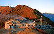
We have had all easy days coming down the Kali Gandaki, but now it's time for some more uphill to cross the Ghorepani pass back to Pokhara. This can be quite a long day, all up hill, especially as it can get hot on the lower slopes if we leave it too late in the day. So we make a good early start, climbing up through the village Ghara (1830m) and Sikha (2080m) before the day warms up. At Phalate (2255m) we have most of the climb behind us and magnificent views of the huge south face of Dhaulagiri, which have been getting better as we go up. We can stop here for lunch or up at Chitre (2330m), if we started early enough. By now we should be enjoy some breeze, and it is really not far to our lodge stop at Ghorepani (2820m). Meaning horse-water this was originally a trader's staging post on the ridge, which has evolved into an important crossroads with many tourist lodges. The views are not bad at all.
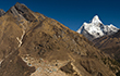
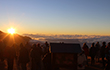
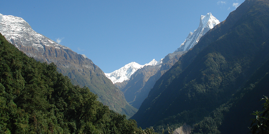
In the morning we rise before the cool, and hopefully crystal-clear, dawn put on our head-torches and, even before breakfast, make our way up Poon Hill(3195m) standing just south of Ghorepani. To be there as the sun rises over the valley of Pokhara, and lights the whole panorama of peaks from Dhaulagiri through Annapurna and Machhapuchhre to Lamjung and way out east, is truly one of the most magical moments in the Himalaya. A wonderful to trek. We descend for breakfast (pre-cooked), and from here it is all downhill, giving back all the height gained yesterday. Hille is small Gurungs village. We spend a night here.
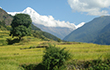
walk along side Bhurundi khola is almost flat but through lovely valley, today is especial day to see a lot of different colorful butter flies. Interesting walking back to Birethanti(1020m) lies at the confluence of Modi Khola and Bhurungdi Khola, it is also where two routes join, with trail from Ghandruk along the Modi Khola meeting the Ghorepani trail near the suspension bridge over Modi Khola at the lower end of the settlement. This village has many good lodges, but as we have fixed itinerary, we prefer to reach Pokhara the same evening. We walk right opposite side of the old trail which provides some extra, this trail was recharged by Lorie one of our clients last year during the trek. About 45 minute walk to Nayapul, is a congested bazaar town with a narrow street crowded with shops: it is from this roadhead that many of the hill folk take their supply of provision. A path leads up from the bazaar to highway and there is a bus stop here. Buses and taxis are usually available for Pokhara from here. Here our private Mini bus or Van will be waiting for your arrival which we'll arrange it in advance. Onboard and our drive will be about 1: 30 hour depends on traffic. We arrive Pokhara, check in hotel and our first priority on hot or cold shower. Our staff will be heading straight to Kathmandu on same day but we will be meeting all of them in Kathmandu for dinner.
We fly back to Kathmandu after our wonderful trek in the foothills of Himalaya. The morning flight drops us at Kathmandu. Our representatives will eagerly waiting for you in the airport to transfer you to the hotel in our private Van/Coach. You can rest and relax throughout the day in your hotel. If you want to explore any other areas of Kathmandu then take the time to do that today! Remember, we will be hosting a fantastic celebration dinner together in occasion of successfully completing your Trek!
Today is free or last minute shopping for souvenirs or gift to your family, friends or relatives for you until your departure flight/drive or to commence any extra trips or activities you may have booked with us. If departing, you'll be transferred to the International Airport for your departure flight to your onwards destination.
| # | Start Date | End Date | Trip Cost | Availability | Booking |
|---|---|---|---|---|---|
| 1 | 7/3//2024 | 31/3/2024 | Cost on Request | Available | Book Now |
| 2 | 28/3/2024 | 21/4/2023 | Cost on Request | Available | Book Now |
| 3 | 5/4/2024 | 30/4/2024 | Cost on Request | Available | Book Now |
| 4 | 15/9/2024 | 9/10/2024 | Cost on Request | Available | Book Now |
| 5 | 1/9/2024 | 25/9/2024 | Cost on Request | Available | Book Now |
| 6 | 5/10/2024 | 29/10/2024 | Cost on Request | Available | Book Now |
| 7 | 25/9/2024 | 19/10/2024 | Cost on Request | Available | Book Now |
| 8 | 20/10/2024 | 13/11/2024 | Cost on Request | Available | Book Now |